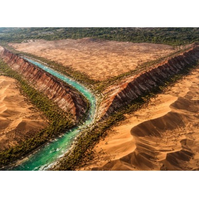
Seen from space, a colossal Y cuts through Chinas largest desert, blending a jade-filled river with red and white mountains and revealing the absurd scale of the Taklamakans transformation surrounded by a green wall of billions of trees.
A satellite image revealed a rare feature in the Taklamakan Desert, where relief, water, jade and vestiges of an ancient military fort intersect at the same point in the landscape in western China.
A satellite image recorded over the Taklamakan Desert, in western China, highlighted a Y formation at the meeting between the Hotan River and the Marztagh mountain ridge. At the same point, there are the ruins of Mazar Tagh, a military fort dating back to the 8th century, in an area associated with the circulation of trade routes in Central Asia. The Taklamakan is in the Tarim Basin, in the Chinese region of Xinjiang, and occupies around 337 thousand square kilometers.In recent studies and reports, the area appears linked both to extreme arid conditions and to desertification containment projects in the surroundings of the desert.How the Y format appears in the landscapeThe design observed from space results from the meeting of two natural features.The Hotan River, also called Khotan, crosses the desert from south to north for around 290 kilometers.For its part, Marztagh is described by NASA as an elongated formation, similar to a wall rocky mountain, which rises around 180 meters above the dunes and extends up to 145 kilometers in a northwest direction. In the image, the river appears in greenish tones due to the vegetation that grows between the channels. Next to it, the rocky ridge stands out for the alternation between reddish stripes, linked to rocks rich in iron, and lighter layers of sandstone. In Chinese, the formation is also called Hongbaishan, an expression that means "red mountain and white". There is also a direct impact on the surrounding relief. Marztagh acts as a natural barrier for sand transported by the wind, favoring the formation of crescent dunes, known as barchanas, especially on the northern edge of the ridge. The Hotan River and the historical presence of jadeIn addition to the stroke, the Hotan is known for the historical relationship with nephrite. Fed by the melt coming from the Kunlun Mountains, to the south of the desert, the river is associated with the presence of white jade. and green jade, materials valued for centuries in the region. This set of characteristics helps explain the historical relevance of the area. The presence of water, relative shelter from the advance of the sand and access to mineral resources transformed this stretch of the desert into a support point for travel and commercial exchanges. The strategic point on the Silk Road The area where the river and the ridge meet was integrated into the network of roads that later became known as the Silk Road. Instead of a single road, it was a system of routes that connected different regions of Asia over several centuries. In this context, the place met practical conditions for circulation and surveillance. It was there that Mazar Tagh was established, a military fort erected at the top of an elevation next to the vertex of the Y.