Forest fires in the world
More than 234,516 hectares of land have already been burned throughout the European Union this year alone
According to data from the European Forest Fire Information System (EFFIS). Devastating forest fires have spread across Greece, Italy, Spain, Portugal, Algeria, Tunisia and Canada in recent weeks, causing loss of life and enormous environmental and economic damage. The situation demands urgent attention and effective measures to combat the growing danger posed by these forest fires.
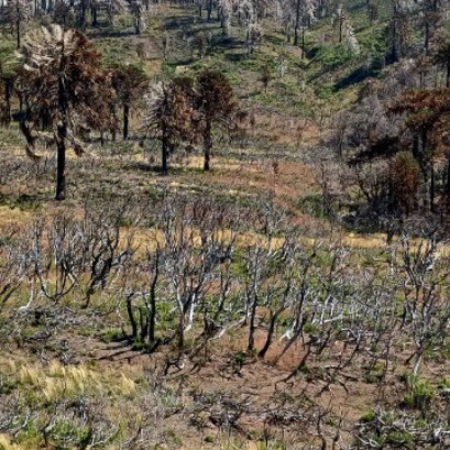
Although forest fires are a natural part of many ecosystems, scientists have warned that they are becoming more frequent and more extensive. In response, an updated version of the ESA World Fire Atlas is now available, offering a detailed analysis of forest fires across the globe.
The increase in global temperatures and the greater frequency of extreme weather events have caused an increase in the number of forest fires that rapidly burn large areas of vegetation and wooded land. Countries like Greece and Italy have already seen the devastating impact of large-scale fires.
According to the European Forest Fire Information System (EFFIS), as of July 29, 2023, more than 234,516 hectares of land have already burned across the European Union this year alone. The situation demands urgent attention and effective measures to combat the growing danger posed by these forest fires.
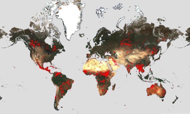
In view of the serious forest fires, the ESA has reactivated its World Atlas of Fires, which allows knowing the distribution of each of the fires that take place both nationally and globally.
Through its interactive panel, users can compare the frequency of fires between countries and analyze their evolution over time. The atlas was first activated in 2019 and has supported both European civil protection agencies and firefighters.
The atlas uses nighttime data from the Sea and Land Surface Temperature Radiometer (SLSTR) on the Copernicus Sentinel-3A satellite. The sensor, which works like a thermometer in the sky, measures infrared thermal radiation to measure11 the temperature of the earth's surface, which is used to detect fires.
Although the atlas cannot capture all fires due to satellite flyover limitations and cloud cover, it is statistically representative month-to-month and year-to-year. Data from the Copernicus Sentinel-3B satellite will be added in December 2023.
In the previous seven years, the World Fire Atlas data shows a considerable number of fires detected in Portugal, Italy, Greece, France and Spain, with the highest number of fires reached in Portugal in August 2016 and October 2017.
The data also shows that Canada has experienced 11,598 fires in the first seven months of 2023 alone. This is an increase of 705% compared to the fires detected during the same period (January 1 to July 31) of the past 6 years (from 2017 to 2022). Canada is currently battling the worst wildfire season on record in the country, with more than 10 million hectares burned, expected to increase in the coming weeks.
Olivier Arino of ESA said: “The relaunch of the World Fire Atlas represents a valuable opportunity for authorities, researchers and organizations to gain a better understanding of fires occurring around the world. Using this comprehensive resource, they can design more effective strategies for the prevention and management of fires on a global scale.
The continued commitment of ESA, Copernicus and the EU to continuously provide this valuable resource reinforces the importance of harnessing space technology to address the most significant environmental challenges."

IT MAY INTEREST YOU
 Specialists from 10 provinces develop forest landscape restoration strategies throughout the country
The program is developed by researchers from INTA, Conicet and the Argentine Wildlife Foundation.
 They promote research in pine resins from the NEA
The forestry industry is one of the most important sectors in the economies of Misiones and Corrientes. Thousands of hectares of pine supply the paper, pulp, boards and sawmill industry. Pinus elliottii, one of the species established in the region, in addition to providing wood, is used to produce resin, a non-wood forest product with high demand in the chemical, pharmaceutical and cosmetic industries. In 2\024, resin extraction of approximately 52,6\0\0 tons was achieved from approximately 18,\0\0\0,\0\0\0 trees in production, generating income and jobs with high expansion potential.
 Paraguay | The plantations became instruments of territorial development and the generation of decent employment, INFONA highlights.
Plantings in different phases, control of ants and weeds, pruning and thinning, mechanized harvest, technology applied to the field and complete integration of the production cycle were part of the CREA Forestal proposal in its Technical Update Conference JAT Forestal 2025. The event took place on Friday, November 14, at Estancia Ñemity, located in San Juan Nepomuceno, Caazapá, where agricultural producers, technicians, contractors, students and companies in the sector met to observe the forestry business of the future in action.